Earthquake of magnitude 5.0 - 5 km SSW of Magsaysay, Philippines
Earthquake of magnitude 5.1 - 178 km ESE of Yigo Village, Guam
Earthquake of magnitude 4.7 - 96 km SW of Tambolaka, Indonesia
Earthquake of magnitude 4.7 - 169 km WSW of Ambon, Indonesia
Earthquake of magnitude 4.6 - 60 km W of Macabuboni, Philippines
Earthquake of magnitude 4.6 - 61 km ESE of Masohi, Indonesia
Earthquake of magnitude 5.3 - 62 km ESE of Masohi, Indonesia
Earthquake of magnitude 4.6 - 50 km E of Modisi, Indonesia
Earthquake of magnitude 4.9 - 66 km WSW of Ternate, Indonesia
Earthquake of magnitude 5.3 - 75 km E of Yigo Village, Guam
Earthquake of magnitude 4.9 - 185 km NNE of Saipan, Northern Mariana Islands
Earthquake of magnitude 5.0 - 22 km NE of Taytayan, Philippines
Earthquake of magnitude 4.6 - 53 km WSW of Cabangahan, Philippines
Earthquake of magnitude 5.6 - 227 km W of Tual, Indonesia
Earthquake of magnitude 4.6 - 30 km S of Giporlos, Philippines
 1 year ago
Reporter: Will you be discussing AUKUS? Trump: What does that mean? Reporter: The Australia U.S. Defense alliance?
Earthquake of magnitude 5.1 - 41 km ENE of Ruteng, Indonesia
Earthquake of magnitude 4.7 - 217 km N of Tobelo, Indonesia
 1 year ago
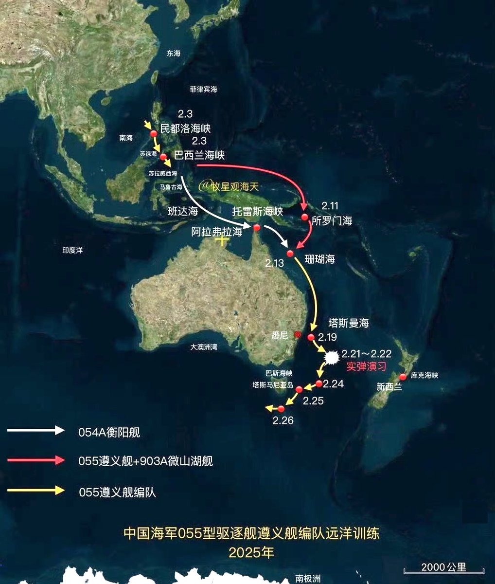
Map from Chinese media showing the route followed by the PLA Navy task force operating off the coast of Australia
Earthquake of magnitude 4.7 - 60 km E of Modisi, Indonesia
Earthquake of magnitude 5.0 - 132 km WNW of Ternate, Indonesia
Earthquake of magnitude 4.7 - 65 km E of Modisi, Indonesia
Earthquake of magnitude 5.1 - 55 km ESE of Modisi, Indonesia
Earthquake of magnitude 4.9 - 58 km E of Modisi, Indonesia
Earthquake of magnitude 4.8 - 58 km ESE of Modisi, Indonesia
Earthquake of magnitude 4.9 - 61 km E of Modisi, Indonesia
Earthquake of magnitude 5.0 - 59 km E of Modisi, Indonesia
Earthquake of magnitude 4.9 - 54 km E of Modisi, Indonesia
Earthquake of magnitude 4.6 - 45 km ESE of Modisi, Indonesia
Earthquake of magnitude 4.9 - 42 km ESE of Modisi, Indonesia